How can we help you?

Get all the answers you're looking for in a search bar below. Let's start now!

Frequently Asked Questions

We now have a list of FAQs to help you discover and learn more about us; get acquainted with our products and services.

1. What does Orbital Africa deals in?

We offer geospatial products and services in the realms of GIS, remote sensing, drone technology, land and topographical surveys; and GIS training. For more details, please refer to our >>> Company Profile.

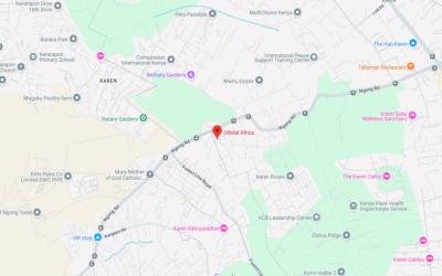
2. Where are your offices located?

Our offices are located >>> Here.

3. Do you offer GIS training courses?

YES. Kindly refer to our training courses catalogue >>> Here.

4. Do you offer attachments or internships?

YES. We offer attachments and internships in the months of Jan, Apr, Jul and Oct. For more details refer >>> Here.

5. What products do you offer?

Please refer to our >>> Company Profile.

6. What services and solutions do you offer?

Please refer to our >>> Company Profile.

7. What do GPR, GNSS, GPS and GIS stand for?

GPR – Ground Penetrating Radar

GNSS – Global Navigation Satellite System

GPS – Global Positioning System

GIS – Geographical Information System

8. How is land, mutation and cadastral survey done?

Kindly refer to this >>> Web Page.

9. What is the topographical survey procedure?

Kindly refer to our documentation >>> Here

10. What other countries do you serve in Africa?

We serve these countries in Africa.
Blog Articles

Explore our blog for insightful articles, emerging technologies and trends in Geospatial world that inspire action on the topics you care about.
Sunnav RTK GNSS
Just explore your World with SunNav GNSS RTK Machine!

SunNav S26 GNSS Real time Kinematics (RTK) Receiver is a high-precision satellite navigation device used primarily in surveying, mapping, and geospatial data collection. The RTK technology enhances the accuracy of GNSS positioning data by using a fixed base station and one or more mobile receivers (rovers). S26 GNSS receiver removes barriers to portability without sacrificing [...]

Read more
GIS Mobile Mapping and Data Collection
GIS Mobile Mapping and Data Collection using Smartphones

In the recent years, we have witnessed an explosive growth in the demand for mobile GIS data collection. This demand has myriad of sources and takes many forms; however, the net effect is an ever-increasing thirst for geospatial data that is more accurate, up-to-date, has higher density, is produced more rapidly, and is acquired less [...]

Read more
Carbon Credits and Offsetting
Step-by-Step Guide to understanding how the Carbon Credits Work

Carbon credits are a market-based mechanism that aims to reduce the emission of greenhouse gases. Carbon credits (CC) are a crucial element in the global effort to combat climate change. They create a market-based approach to controlling pollution by providing financial incentives for reducing emissions. The companies or entities that emit less than their allotted [...]

Read more

Orbital offers unmatched products and solutions in Africa!

Get started
Learn more about Orbital’s unique solutions.