A Land Information and Management System (LIMS) is a web and mobile based business solution that will streamline and automate the critical processes associated with land obligations and payment. LIMS is a comprehensive and integrated system that manages and provides information related to land and its use. It combines spatial data (geographic information) with attribute data (non-spatial information) to create a database that supports various land-related applications. LIMS is commonly used by government agencies, land management organizations, and urban planners to make informed decisions about land use, land development, and natural resource management.
LIMS is a tool for legal, administrative and economic decision-making and an aid for planning and development. It consists of, on the one hand, a GIS database containing spatially referenced land-related data (parcels) for a defined area and, on the other hand, procedures and techniques for the systematic collection, updating, processing and distribution of the data. The base of a land information system is a uniform spatial referencing system, which also simplifies the linking of data within the system with other land-related data e.g. zoning, taxation etc.

Key Aspects and Functionalities of LIMS
-
Spatial Data Management: The GIS (Geographical Information System) technology is often a core component of a Land Information System. GIS allows the storage, analysis, and visualization of spatial data, such as maps, satellite imagery, and other geospatial datasets.
-
Cadastre Information: LIMS typically includes information about individual land parcels, including ownership details, land use classifications, land tenure and legal descriptions. This data is very crucial for property assessment, taxation, as well as land management.
-
Land Use Planning: LIMS supports land use planning by providing tools to analyze the current land use patterns, assess the impact of potential developments, and formulate strategies for sustainable land use.
-
Environmental Management: It helps in monitoring and managing environmental resources by incorporating data on ecosystems, soil types, vegetation, water bodies, minerals and other natural features.
-
Zoning and Regulation Compliance: LIMS can assist in enforcing zoning regulations by tracking land use changes, ensuring compliance with zoning laws, and facilitating the permitting process.
-
Infrastructure Planning: Urban planners use LIMS to plan and manage infrastructure development, such as roads, utilities, and public facilities, by considering the spatial relationships between different land uses.
-
Natural Resource Management: It plays a crucial role in managing and conserving natural resources, including forests, water resources, and agricultural lands. LIS can aid in monitoring changes in land cover and assessing the impact of land use on ecosystems.
-
Disaster Management: LIMS can be employed in disaster management by providing spatial information for risk assessment, the emergency response planning, and post-disaster recovery efforts.
-
Decision Support System: It serves as a decision support tool by integrating diverse data sources and providing analytical capabilities to support informed decision-making processes related to land management.
-
Public Access and Transparency: Many LIMS implementations include web-based interfaces or public portals that allow citizens and stakeholders to access land-related information, thus promoting transparency and public engagement.
Orbital Africa, a company based in Kenyahave developed a very comprehensive LIMS platform leveraging on GIS portal with capabilities of handling both data and location analytics.
Location Analytics with LIMS

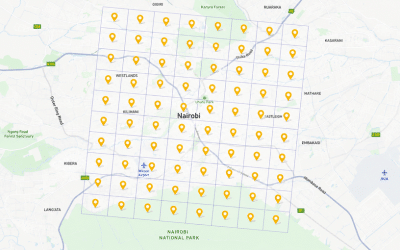
With LIMS, you can visualize your Land Assets, and Land Records on an Interactive GIS Map. Below are some of the capabilities of the LIMS with respect to location analytics:
-
View parcel coordinates, Surface features, Waterbody, Road and Railway, Mineral assets, etc.
-
Integration of parcel map with ownership records through geographic indexing.
-
Mapping & Management of multi-locational land assets across units.
-
Satellite images/ Google/ Bing Map integrated on a background as background imagery.
-
Map tools available for Basic editing, Navigation, Drawing, Map inquiry, Geo-processing.
-
Easy-to-use mobile app for field inspectors with inspection notifications and GIS display of site location map.
-
Field personnel can record inspections in the field (online & offline) with geo-tagged photographs, data, signatures etc.

Orbital Africa’s Land Management Solution is entirely customisable to suit everyone’s needs. Available in mutiple versions it can adapt to your requirement. It comes in three licensing levels i.e. LAMS for Starting out, LAMS for Experienced and LAMS for Enterprise.
Data Analytics with LIMS

- Central storage of Land registry with recording, indexing and archiving land records and transactions for sellers, buyers, owners and lenders.
- Full registry automation and historical records of ownership and encumbrance transactions for parcels.
- Parcel management activities like splitting, amalgamating, and subdividing can be handled through the portal.
- Fully compatible with all mobile, tablet, and desktop devices.
- Property valuation tool to calculate using market value, sale price, taxable market value and tax category.
- Online Permit management with Permit Requests, Request or renew business licenses and online payments.
- Responsive Workflows with tasks creation, schedule, assign, track and approval.
- Email and message notifications.
- Customized Dashboard and Industry Standard Reports downloadable in PDF and Excel.
- Smooth implementation with Live help desk, Web support library, User training.

Therefore, in summary, LIMS consists of an accurate, current and reliable land record cadastre and its associated attribute and spatial data that represent the legal boundaries of land tenure in a given locality and provides a vital base layer capable of integrating other geographic systems or as a standalone solution that allows data retrieval, creation, updating, storing, viewing, sharing, analyzing and publishing the land information.
GIS training courses: Here ++ | Blog: orbital.co.ke/blog/ |E-mail address: [email protected] | WhatsApp No: +254 719 672 296
Ad: Explore the world with Expedia

Flewflew: AI solutions provider in Africa

OrbiCollect: Mobile mapping made easier!

NSE Stock Market: Buy & Sell Shares