Reliable
Cost effective
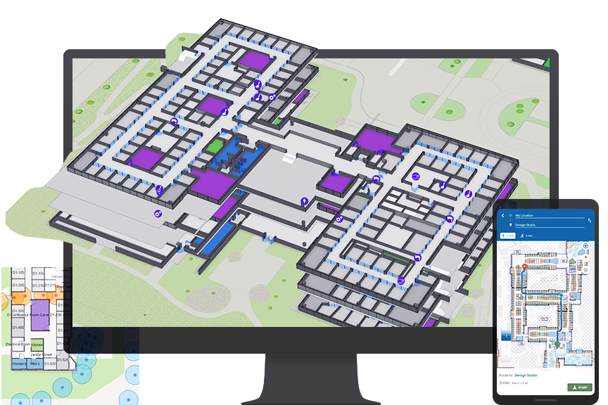
Navigation
Indoor mapping
Indoor GIS, mapping and navigation at your fingertips!
GIS indoors enables your organization to build an indoor geographic information system (GIS) and put the power of indoor mapping, wayfinding, and space management software into everyone’s hands. Your organization can consolidate your asset and space information into a single place, the indoor map, and provide easily accessible web and mobile apps, for location discovery, way-finding, room reservations, and
space planning. Indoor mapping allows leaders to plan and manage space more efficiently. With visual mapping tools, organizations can consolidate unused space to reduced leased square footage or reallocate it to business units that can maximize the space asset to better serve their mission. Organizations can also plan the use of the new space needed for growth and expansion.
Benefits of indoor GIS mapping
Combine your CAD and BIM data into a single geospatial system of record using GIS indoor maps.
1) Digital, easy-to-navigate indoor maps
With the single source of indoor data, create intuitive and easily understood floor-aware indoor maps that highlight people, places, and assets.
2) Effective and faster service delivery
Assets and equipment need regular maintenance, and indoor mapping and way- finding software in the hands of IT, facilities, and security personnel helps them save precious minutes in responding to work orders, knowing exactly where and how to get to their work. Those minutes add up to countless hours and cost savings.
3) Build a safer and reliable workplace
With a shared map, leaders can have the same knowledge that their teams have, at any time. If there’s a maintenance or security issue, they’ll know right away. They don’t need to wait for staff to find paper blueprints or convey status information. In turn, they can make fast decisions to avoid work disruptions and keep employees and visitors safe.
4) Put indoor maps into everyone's hands
Give everyone access to indoor maps with GIS indoors mobile app. Empower space planners with space management maps for use in the app. GIS indoor mapping provides complete situational awareness of your space, giving operations staff and decision-makers crucial location intelligence.
5) A hybrid workplace with indoor GIS
The hybrid workplace has rapidly become the new norm, and employees and visitors need to know they have space, equipment, and amenities they need; where to find them; and how to get them on days they are at work.
Details on indoor mapping? get in touch!
Utilize the power of indoor GIS and mapping to analyse and discover the hidden information in by visualizing all your indoor data within a digital indoor map.
