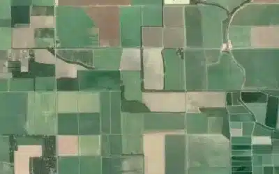
The Kenyan duo; Mr. Linus Anari, a Geospatial Engineering student at the University of Nairobi (UoN), and Ms. Eileen Mburu, a Geographer, have brought pride to Kenya by emerging victorious in one of the prestigious global competition organized by the National Aeronautics and Space Administration (NASA). The two young innovators were among the winners of the Pale Blue Dot Challenge, a competition aimed at addressing some of the world’s most pressing issues, including climate change, water scarcity, and food insecurity. They developed an interactive Geographical Information System (GIS) to identify some food security hot spots in Northern part Kenya. The challenge attracted a total of 1,600 competitors and innovators, 70% of whom had never worked with Earth observation data before. Participants came from all around the globe, representing over 100 different countries including USA, Mexico, Brazil, Botswana among others. Throughout the competition, more than 130 submissions were received.

NASA Pale Blue Dot Challenge is a prestigious initiative aimed at inspiring global audiences and innovators to engage in the exploration of Earth and space, taking inspiration from the famous “Pale Blue Dot” image and speech by Scientist and Astronomer Carl Sagan. The challenge draws its name from the iconic photograph taken by the Voyager 1 spacecraft in 14th February 1990 from an unprecedented distance of approximately 6 billion kilometers! The image showed the Earth as a tiny speck (dot) in the vastness of space, underscoring the fragility and preciousness of our planet. Voyager 1 spacecraft was launched in 1977 with the initial purpose of studying the outer Solar System and the interstellar space beyond the Sun’s heliosphere. Its real-time distance and velocity data are provided by NASA. At a distance of 164 Astronomical Unit (AU) (24.5 billion km) from Earth as of September 2024, it is the most distant human-made object from Earth!

The purpose of blue dot challenge is to encourage participants to explore themes related to Earth, space exploration, and humanity’s place in the universe. It usually involves creative submissions that express these ideas through various forms like art, writing, photography, or other media. The participants are often asked to reflect on our responsibility toward the planet, the importance of scientific discovery, and the unity of humankind in the cosmic context. The challenge typically engages a wide range of people, from students to professionals and artists, urging them to contribute their perspective on these universal themes. It also aligns with NASA’s broader mission to promote space exploration and environmental stewardship, whilst celebrating the legacy of Carl Sagan’s powerful message. NASA uses such initiatives to educate the public about space, connect people with its missions, and inspire the next generation of scientists, innovators as well as explorers.
Best Overall Prize
According to DrivenData website, the following five teams drawn from different countries will have the opportunity to attend a 10-day Space Study program with travel, lodging, and tuition covered by NASA: EE Frogs (USA and Mexico); H2plastic (Brazil); Hunatek-Kalman (USA); Spatial Clan (Kenya); Viva Aqua (USA, Senegal and Argentina).

“Our GIS tool isn’t just about mapping; it’s about saving lives by ensuring resources are directed where they’re needed most,” Linus emphasized. Their innovation is designed to guide targeted interventions, helping authorities and humanitarian organizations mitigate the impact of extreme weather events on food security.
Currently serving as the Chairperson of the (GESA) Geospatial Engineering Students’ Association (2024/2025), Linus is well-known for his passion for leveraging spatial data for innovative solutions in Geospatial realms. His key skills include GIS modelling, remote sensing, cloud computing, GPS technology, and land surveying.
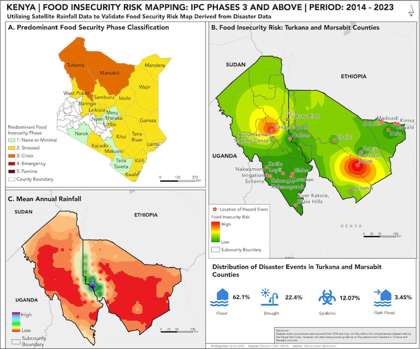
On the other hand, Eileen has a background in Geographic Information Systems (GIS), and is currently working in the application of GIS methodologies to address climate change challenges, including mitigation, adaptation, and resilience efforts among other Geospatial applications. Linus and Eileen were motivated to participate by the devastating impact of prolonged floods in Northern Kenya, a region that had earlier suffered from extended droughts due to El Niño rains during the October – November – December season. They integrated disaster data with spatial analyses to pinpoint food security hotspots in counties like Turkana and Marsabit, regions frequently at the crisis stage of food insecurity.
For their outstanding work, Linus and Eileen have been awarded an all-expenses-paid, 10-day space study program in the United States. Their achievement not only brings pride to Kenya but also sets a new benchmark for the role of technology in addressing real-world problems. Furthermore, their innovation is designed to facilitate targeted interventions, enabling authorities and humanitarian organizations to mitigate the impact of extreme weather events on food security in the region. The system is expected to revolutionize the way agricultural production and livelihoods dependent on agrifood systems are spatially integrated into food security assessments in Kenya.
In this project, the engagement with the community revealed that, even as North Eastern region anticipate El Niño rains, the region is inevitably bound to return to drought conditions, creating a repetitive cycle. The firsthand experience of the community’s challenges and their resilience inspired our interest in exploring how Geographic Information Systems (GIS) could provide insights into food security hotspots, facilitate targeted interventions, and minimize the impact of extreme weather events and disasters on food security in the region.
Food and nutrition security assessment reports in Kenya, conducted by the Kenya Food Security Steering Group and made publicly available by the National Drought Management Authority (NDMA), evaluate various factors within each county to determine its current food security phase classification. Disasters, known to jeopardize agricultural production and the livelihoods of millions reliant on agrifood systems, are seldom integrated into spatial analyses in food security assessments. They chose to incorporate disaster data to spatially disaggregate food security assessments in counties predominantly classified in Crisis stage 3, i.e., Turkana and Marsabit. They then validated their findings using satellite rainfall data, a crucial factor directly influencing food security.
SeitoBnB – Vacation Houses Listing Platform >>>

Cities & Towns: Nairobi, Mombasa, Kisumu, Nakuru, Eldoret, Kisii, Nyeri, Nanyuki, Kericho, Kiambu, Voi and more…
Ad: Explore the world with Expedia

Flewflew: AI solutions provider in Africa

OrbiCollect: Mobile mapping made easier!

NSE Stock Market: Buy & Sell Shares

Join Binance and Let us win together!

AGM 6th Edition: Jan-Apr 2025