ORBITAL AFRICA will commit its best efforts to complete the 176 points agreed upon in Tasking Order as soon as practically possible. ORBITAL AFRICA must ensure that no fewer than 176 points are completed at least. Deliver no less than 55 points to SRS every week. For points that cannot be measured, ORBITAL AFRICA needs to provide detailed evidence (government documents, photos, etc.). If ORBITAL AFRICA encounters any matters that affect the progress during fieldwork.

The data shall be referenced to the standard datum WGS84 (ITRF2020) and the dynamic epoch specified by the collection/acquisition date. Latitude and longitude shall be reported in decimal degrees to 8 decimal place precision. Elevation in Height above Ellipsoid (HAE) both in WGS84 shall be reported in meters to 3 decimal place precision. Points are to be processed by NRC-PPP (National Resources Canada – Precise Point Positioning) online GNSS data post-processing service. Output NRC-PPP processing sheets shall be included within the delivery package and the result coordinates and accuracies saved in a CSV file, indexed with the GCP IDs / codes. Coordinates will be prepared in Coordinates Reference Systems, WGS84.

CSRS-PPP
The Canadian Spatial Reference System Precise Point Positioning (CSRS-PPP) is an online geodetic software service provided by Natural Resources Canada. It processes Global Navigation Satellite System (GNSS) data to determine high-accuracy positions anywhere on Earth. The service is widely used in surveying, geoscience, and navigation research for its global precision and free accessibility. The CSRS‑PPP is an online post-processing service for high-precision GNSS positioning.
Key facts
-
Provider: Natural Resources Canada (NRCan)
-
Launch year: 2003
-
Primary function: Precise GNSS data processing and coordinate computation
-
Input formats: RINEX GNSS observation files
-
Output: Geocentric and geographic coordinates in global and Canadian reference frames
What it does
- Processes raw GNSS observation data to compute precise point positions.
- Uses high-accuracy satellite orbits and clocks to achieve centimeter-level accuracy without needing a local base station.
- Works with dual-frequency GNSS data collected by survey-grade receivers.
How it works (workflow)
- You record raw GNSS data (e.g., RINEX files) in the field.
- Upload the data to the CSRS-PPP service.
- The service applies precise satellite ephemerides, clock corrections, and atmospheric models.
- You receive refined coordinates in standard reference frames.
Why it’s useful
- Eliminates the need for a local reference station or real-time corrections.
- Provides high-accuracy results for surveying, mapping, engineering, and geodetic applications.
- Supports static and kinematic processing modes.
Typical accuracy
- Static mode: centimeter-level precision (after longer observation sessions).
- Kinematic mode: decimeter- to centimeter-level accuracy depending on conditions.
If you want, I can walk you through a sample workflow—e.g., how to prepare a RINEX file, submit it, and interpret the output report.
Operation and methodology

CSRS-PPP applies Precise Point Positioning (PPP) techniques using precise satellite orbit and clock products from the International GNSS Service. Users upload RINEX data, and the system computes coordinates through a combination of pseudorange and carrier-phase observations. The results are expressed in both the International Terrestrial Reference Frame (ITRF) and Canada’s NAD83(CSRS) reference system. Processing modes include static, kinematic, and rapid post-processing.
Accuracy and performance
Under optimal conditions, CSRS-PPP achieves horizontal accuracy within a few centimeters for static solutions and decimeter-level accuracy for kinematic analyses. The service automatically applies models for atmospheric delays, satellite biases, and Earth orientation parameters, enabling global consistency without the need for local base stations.

Submitting GNSS data to CSRS-PPP service
Once the logs are downloaded, export them to your PC in a preferred way and submit the data to NRCan CSRS-PPP for processing.
-
Go to NRCan CSRS-PPP official site.
-
Click the Sign in button and enter your login and password to access the NRCan CSRS-PPP submission page or create a new account in case you don’t have it yet.
-
In the Email for results field, enter your email address to get the results.
-
In Processing mode, choose Static.
-
Choose the datum in which you would like to get the position. In this guide, we will work with the ITRF option.
-
In the RINEX observation file field, click the Choose file button and browse for the observation file (.**O).
-
Click the Submit to PPP button to send the file for processing.
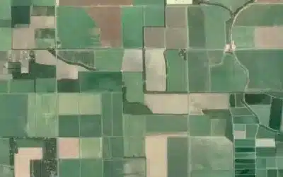
- Ground control points shall be distributed evenly through the project’s AOI.
- Centralized measurement points will be on average a grid of 20 or 20km. There will be 2 points per 1 cell of a grid. Grid was provided to the surveyor as a part of the image chips KML file.
- Preferred feature are right angles and strong contrast are preferred.

Angle of the road intersection work as well. If it is a right Angle, that would be the best. If there are no right angles. Acute angles or obtuse angles that can be clearly identified are also acceptable.
All features surveyed must be identifiable on 0.5 – 5 m GSD imagery, so a minimum feature size of 2 by 2 m is required. No dimension of the feature shall be smaller than 2 m. If there is a good feature of required dimension and in line with other general guidelines (contrast, sky-view, vertical offset) listed in next section, surveyor can prioritize corner of such feature over the “intersection” type of feature.
Challenges Experienced
Lack of mobility and poor accessibility: Another major obstacle was the lack of mobility within the survey area. The region had very limited road infrastructure, with some locations being entirely inaccessible by vehicle. The rough terrain and absence of defined roads made it difficult for the team to transport GNSS equipment and other survey tools to designated points.
Interference from local politicians and administrators: During the fieldwork, the survey team also faced interference from local political leaders and administrators who questioned the legitimacy of the project. The several calls were received from these individuals, instructing the team to halt their activities until further clarification was provided.
Poor mobile network and internet connectivity: Communication in the field was significantly hindered by weak or non-existent network and internet signals. In many areas, mobile networks were unreliable, making it difficult for field crews to coordinate, share updates, or upload data to the central system in real time.
Difficulty in identifying survey points on the ground: Finally, another major challenge was the difficulty in accurately identifying pre-selected survey points on the ground. Even where coordinates were provided, the absence of visible or permanent reference markers made it hard for the field team to confirm exact point locations.
Ad: Explore the world with Expedia

Flewflew: AI solutions provider in Africa

OrbiCollect: Mobile mapping made easier!

NSE Stock Market: Buy & Sell Shares

AGM 6th Edition: Jan-Apr 2025