
Introduction to AI and GeoAI
Artificial Intelligence (AI) is an evolving technology that tries to mimic human intelligence using machines. AI refers to the development of computer systems that can perform tasks that typically require human intelligence. These tasks include learning, reasoning, problem-solving, perception, language understanding as well as decision-making. AI encompasses a wide range of techniques, methodologies, and applications, with machine learning being one of its most prominent subfields. Machine learning (ML) is a subset of AI. It focuses on developing algorithms and statistical models that enable computers to learn from and make predictions or decisions based on huge amount of data. There are various types of machine learning approaches, including supervised learning, unsupervised learning, semi-supervised learning, reinforcement learning and deep learning.

In Geospatial realm, GeoAI (Geospatial combined with AI) refers to the integration of spatial analysis techniques with AI technologies to analyze and derive insights from geospatial data such as satellite or drone images. GeoAI has transformed geospatial analysis by enabling more efficient processing of vast volumes of spatial data, extracting valuable insights, and enhancing decision-making in various domains. GeoAI leverages the spatial context inherent in geographic data to enhance the capabilities of AI systems in order to solve complex spatial problems.
Why AI in GIS, Survey and Mapping?
The importance of AI stems from its transformative potential to revolutionize Geospatial industry, improve efficiency, enhance decision-making, and address complex spatially related societal challenges. AI is significant in GIS, survey and maping in many ways. Below are some of the examples o its applications:
Spatial Data Analysis: It enables the analysis of huge volume of geospatial data, including satellite and drone imagery, aerial photographs, LiDAR data, GNSS data and demographic data, to extract valuable insights about spatial patterns, relationships as well as trends.
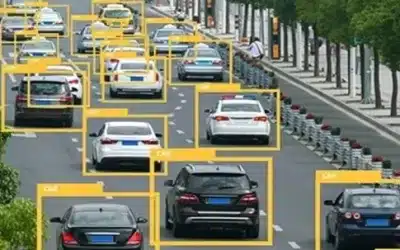
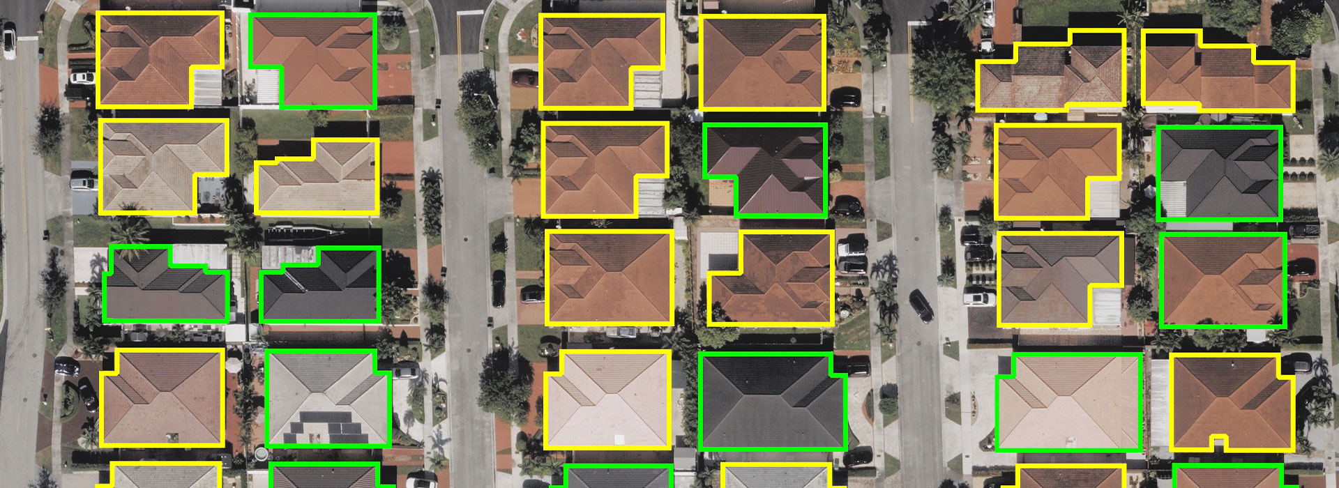
Image Classification and Object Detection: GeoAI algorithms are applied to satellite or aerial imagery to classify land cover types, detect objects such as buildings, roads, water bodies and vegetation including identification of changes in the landscape over a given period of time. This is essential for tasks such as land use planning and management, environmental monitoring and disaster response.

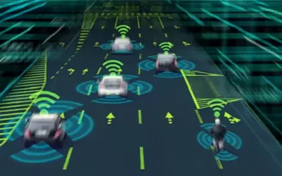
Geospatial Navigation and Routing: GeoAI has significantly enhanced the efficiency and accuracy of navigation systems. ML algorithms can predict traffic patterns in real time, optimize the routes and provide updates on-the-go to the users. These algorithms consider factors such as traffic congestion, road conditions and spatial constraints to provide efficient navigation solutions. They analyze huge amounts of data from various sources, including traffic sensors, CCTV cameras, GPS data, and social media feeds, to offer the most efficient navigation solutions especially in urban areas or cities. AI algorithms can also analyze large amount of data such as historical traffic patterns, road conditions and user preferences, to generate personalized and efficient routes. Google maps navigation and routing platform is one of such systems that employ AI in providing routes with less traffic or congestion to a road user.
Geospatial Data Fusion: GeoAI integrates heterogeneous geospatial datasets from multiple sources to create comprehensive spatial databases. By fusing data from different sensors and modalities, it enhances the understanding of complex geographic phenomena such as flooding or traffic congesition in cities thus supports decision-making in various multi-faceted domains.
Also read this captivating article about What will the World look like 30 years from today?
Location Intelligence: The technology provides location-based insights and analysis to businesses, governments and organizations. It helps in the site selection, market analysis, supply chain optimization, and customer segmentation by leveraging spatial data and AI techniques.
Spatial Predictive Modeling: GeoAI models are capable of predicting spatial phenomena such as urban growth, wildlife habitat suitability, disease spread and transportation patterns. Thus, by combining the spatial analysis with ML algorithms, GeoAI enables the forecasting of future spatial relationships, trends, patterns and scenarios.
Smart Cities and Urban Analytics: GeoAI supports the development of smart cities by analyzing urban data to improve infrastructure, transportation, public services, and urban planning. It helps cities optimize resource allocation, reduce environmental impact, and enhance quality of life for residents.
The future of GeoAI – We’re not there, yet!
The future of Geospatial AI holds immense potential to address some of the most pressing challenges facing the society, from climate change, flooding and urbanization to food security and disaster resilience. For instance, Hexagon tools have been developed to make it easier for users to train artificial intelligence to recognize and categorize the “hundreds of thousands of samples” in the spatial dataset.
According to Geospatial World publication, Geospatial solutions like Hexagon’s ERDAS IMAGINE remote sensing software package, ImageStation for large-scale mapping and M.App X for cloud-based analysis, already employ AI and will continue to become more powerful as algorithms evolve. That increase in analytic power from neural networks and machine learning makes better geospatial intelligence possible, said Ian Anderson, chief product owner for ERDAS IMAGINE. For instance, using AI, it is possible to map the location and track the movements of “every F-16 in the world,” Anderson said, or more accurately track the effects of global climate change or shifting vegetation patterns worldwide!
But AI can’t do the job by itself. It only helps human analysts handle a volume of data that wouldn’t have been possible without the use of AI. Artificial intelligence, despite the name, “is fundamentally dumb,” said Dr. Kuan Collins, Executive Director of Digital Innovation at Axient, and a panelist at the Geospatial Advantage Conference. “Human beings have to make it intelligent. We need to get past the fear factor, for sure, and I think education is the key.”
However, unlike many other industries, we do not expect AI to replace the role of a surveyor or Geospatial analyst. Instead, AI-powered software solutions and tools will continue to help surveyors collect, process, and analyse large amounts of data, making it easier to map out land features, identify potential hazards, and assess the impact of development projects. “I would say that AI is not a destination, it’s a journey,” Jeffries said. “We have to embrace it. We can’t push back.”
In conclusion, GeoAI provides new opportunities for surveyors and Geospatial analysts to enhance their knowledge and understanding, thus making them more competitive in the workplace. By seizing these opportunities, workers can remove the risk of being left behind and advance their job skills through learning and being at pace with technological changes and trends.
AGM 5th Issue