GIS is an extensive information system that enables modernization of workflows with easy-to-use applications for the field and office. GIS Strengthens organizations with smart water solutions that increases efficiency and provide insight for decision-makers. The water utilities’ core function is the timely, orderly movement of water flows, wastewater, and stormwater. This publication discusses how GIS is the foundation for digital water transformation. The GIS facilitates integration, coordination, and analysis of disparate hardware and software, workers and processes, and departments & datasets across space and time.
Key Applications of GIS in Water Utility Management
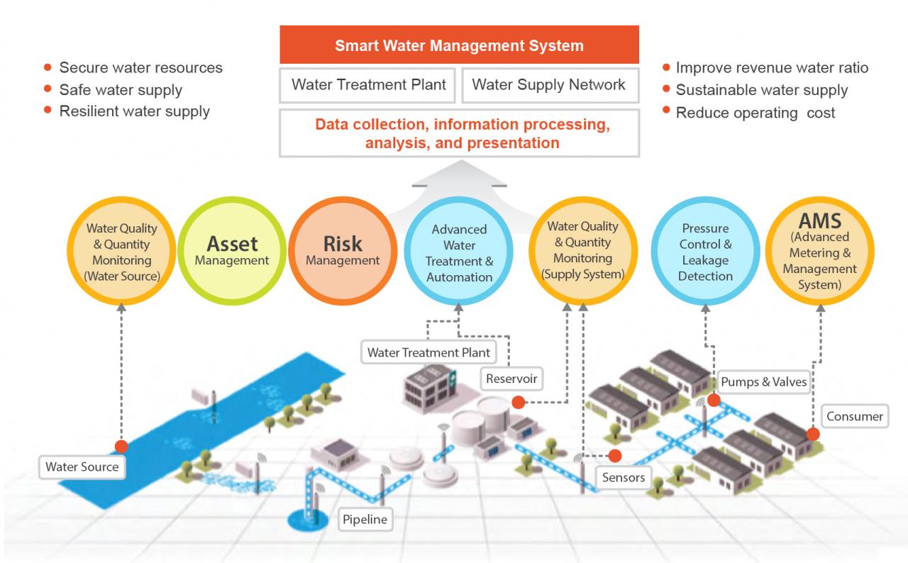 Asset Management: GIS allows water utilities to maintain detailed inventories of their infrastructure assets such as pipelines, pumps, reservoirs, treatment plants, and valves. By integrating asset data with spatial information, utilities can efficiently track asset locations, conditions, maintenance schedules, and lifecycle costs. In Network Modeling and Analysis, GIS enables the creation of digital models of water distribution networks, facilitating hydraulic analysis, flow simulation, and scenario evaluation. Utilities can use GIS-based models to optimize network design, identify potential issues such as leaks or pressure problems, and plan for system expansion or upgrades.
Water Quality Monitoring: GIS can integrate data from various sources including water quality sensors, sampling locations, and historical records to monitor and analyze water quality parameters such as pH, turbidity, dissolved oxygen, and contaminants. Spatial analysis tools help identify patterns, trends, and potential sources of pollution, supporting decision-making for water quality management and regulatory compliance. In Disaster Management, GIS provides valuable support for emergency response planning and coordination during water-related disasters such as floods, droughts, or contamination events. By overlaying real-time data on flood extents, evacuation routes, infrastructure locations, and population density, utilities can quickly assess risks, prioritize response efforts, and communicate with stakeholders effectively.
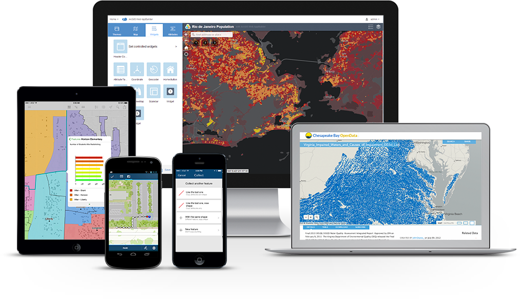 Customer Service and Engagement: GIS-based mapping applications can be utilized to provide customers with access to information about their water service, including billing, consumption patterns, outage notifications, and conservation tips. Interactive maps and web portals empower customers to report issues, track service requests, and participate in water conservation initiatives. In Regulatory Compliance and Reporting, GIS aids in compliance with regulatory requirements by facilitating the spatial analysis of environmental data, monitoring regulatory boundaries, and generating reports for regulatory agencies. Utilities can use GIS to demonstrate compliance with water quality standards, watershed protection regulations, and other environmental mandates.
Water Infrastructure Planning: GIS supports long-term planning and decision-making by helping utilities assess infrastructure needs, prioritize capital investments, and optimize resource allocation. Spatial analysis tools can evaluate factors such as population growth, land use changes, infrastructure aging, and environmental constraints to develop strategies for sustainable water resource management. GIS is also utilised in Water Risk Assessment and Vulnerability Mapping. It enables utilities to identify and assess risks to water supply infrastructure from natural hazards, climate change impacts, cybersecurity threats, and other vulnerabilities. By mapping critical assets, hazard zones, and exposure pathways, utilities can develop mitigation strategies and resilience plans to safeguard water supply reliability and security.
During the Month of February 2024, Orbital Africa was contacted and contracted by Shah Technical Consultants Pvt. Ltd. to offer a one (1) week GIS training services to technical staff from Addis Ababa Water and Sanitation Authority (AAWSA). The training on GIS applications for water utility involved equipping the professionals with the necessary skills to utilize GIS technology effectively in managing the water resources, infrastructure, and operations. The following program was adopted:
Day 1
- Morning: Introductions to GIS; Definition of terminologies; Objectives and components of GIS; The hardware, software, data, people & protocols; GIS Applications in water utility; QGIS vs. ArcGIS.
- Afternoon: The nature of GIS Data – Tabular, Raster (Images) and Vector data (points, lines and polygons); Data Management; Creating shapefiles – Point, Polyline and Polygon; GIS data topologies (Map & Database topologies).
Day 2
- Morning: Coordinate or Spatial Reference Systems; Geographic coordinate systems; Projected coordinate systems; UTM: Georeferencing raster data; Digitizing in GIS; Querying of GIS attribute table; spatial queries; Static maps vs. Dynamic and online maps.
- Afternoon: GIS Analysis Workflows – Buffer, intersect, Count Points in Polygon, Union, Extract, Lines segment count, and Clip operations; Creating GIS analysis maps.
Day 3
 Morning: Cartography: Map design and Production for water utility networks; Viewing maps; zooming and panning; fixed and zoomable map scale; Advanced GIS Water Network analysis operations; Service Area analysis.
- Afternoon: Introduction to the QGIS Model Builder (MB) for automating geo-processes in GIS; Model Builder tools; Create-Save-Test-Run (CSTR) model operations; Debugging the GIS model.
Day 4
- Morning: GIS water distribution systems modeling; water flow analysis; Spatial Multi-criteria Evaluation (SMCE); Flow accumulation; Downloading a DEM using SRTM QGIS plugin; Creating Slope, Hillshade, Aspect; Elevation profiles.
- Afternoon: Waste water network spatial interpolation calculations, water network elements, water distribution modelling, watershed delineation and water catchment analysis.
Day 5
- Morning: Creating a Surface from point data; use of contours, Digital Elevation/Terrain Models (DEMs and DTMs) to analyze wastewater flow, direction and distance using Raster calculations.
- Afternoon: Summary/Recap of the training; Training evaluation and feedback; and Q&A; Winding up the training; Issuance of the training certificates.


