Need a smart GIS app or dashboard? Talk to us

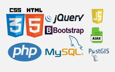
The design and development of a smart GIS app or dashboard requires technical skills. In today’s world, AI has revolutionized every sector. GIS has evolved far beyond static maps. Today, organizations demand smart GIS applications and dashboards that integrate real-time data, analytics, and user-friendly interfaces to support decision-making. Whether applied in urban planning, logistics, agriculture, or fintech asset tracking, a well-designed GIS dashboard transforms raw spatial data into actionable intelligence.

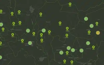
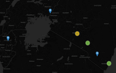
A smart GIS app or dashboard (e.g OrbiCollect) is an advanced mapping system that combines spatial data with real-time analytics, interactive visualization, and user-friendly design to support decision-making. Unlike traditional maps, it integrates features such as dynamic filtering, heatmaps, data overlays, and API connections to external systems like GPS devices or financial platforms. Built on technologies like Leaflet, spatial databases, and modern web frameworks, it enables users to capture, manage, and analyze location-based data efficiently.

The AI powered GIS technology represents a significant evolution from traditional mapping tools, combining geospatial data with real-time analytics and modern user interfaces. It is designed not just to display locations, but to provide meaningful insights that support planning, monitoring, and decision-making across multiple sectors. By integrating spatial intelligence with dynamic data systems, organizations can move from reactive to proactive operations.

At its core, a smart GIS system connects multiple data sources into a unified platform. These may include spatial databases, user-generated inputs, GPS coordinates, and third-party APIs. The result is a centralized environment where geographic and non-geographic data coexist, allowing users to analyze relationships, trends, and patterns efficiently.

GIS Smart App and Dashboard
Orbital Africa’s OrbiCollect GIS Smart App and Dashboard

The visualization layer plays a critical role in making GIS systems usable. Modern dashboards leverage interactive map engines such as Leaflet or Mapbox to present data in intuitive formats. Users can zoom, filter, and interact with layers, transforming complex datasets into accessible visual narratives. This interactivity is essential for both technical and non-technical users.

A key characteristic of a smart GIS dashboard is its ability to handle real-time or near real-time data. For example, in logistics or incident reporting systems, data updates instantly as new inputs are received. This ensures that decision-makers are always working with the most current information, improving responsiveness and operational efficiency.

User experience (UX) is another defining factor. Smart GIS applications are designed with clean interfaces, responsive layouts, and intuitive navigation. Features such as sidebars, pop-ups, and off-canvas menus allow users to access detailed information without overwhelming the screen. The goal is to simplify complex workflows while maintaining powerful functionality.

Data interaction capabilities elevate the usefulness of a GIS dashboard. Users can perform advanced queries, apply filters, and conduct spatial analysis directly within the interface. The common functionalities include:

  • Searching by location, ID, or attributes
  • Filtering datasets by date, category, or status
  • Selecting areas on the map to analyze specific regions
  • Dynamically updating results without page reloads

Analytics integration further enhances the intelligence of the system. Charts, graphs, and summary metrics can be embedded alongside maps to provide deeper insights. For instance, a dashboard might display trends in incidents over time, distribution of assets across regions, or financial values tied to specific locations.

Offline functionality is increasingly important, especially for field-based applications. Smart GIS systems can store data locally on devices using technologies like IndexedDB, allowing users to continue collecting and viewing data without internet connectivity. Once a connection is restored, the system synchronizes with the central database, ensuring data consistency.

Security and system integration are also critical considerations. A robust GIS dashboard includes role-based access control, secure APIs, and proper data validation mechanisms. It can integrate with external systems such as payment platforms, IoT devices, or enterprise databases, making it part of a broader digital ecosystem rather than a standalone tool.

Orbicollect Smart GIS Map  App
Orbicollect Smart GIS Map Application with Leaflet Cluster

A smart GIS app or dashboard is more than a mapping solution—it is a comprehensive data intelligence platform. By combining real-time data processing, interactive visualization, analytics, and seamless integration, it empowers organizations to make informed, data-driven decisions. As technology advances, these systems will continue to play a central role in sectors such as survey, incidents mapping, land management, urban planning, agriculture, logistics, and financial asset management.


GIS training courses: Here ++ | Blog: orbital.co.ke/blog/ |E-mail address: [email protected] | WhatsApp No: +254 719 672 296 

Leave a Reply

Your email address will not be published. Required fields are marked *

Create Questionnairres and Surveys Forms

OrbiCollect-Mobile Data Collection App


OrbiCollect: Mobile data collection made easier for organizations and individuals! 

This will close in 20 seconds

Translate »