In March 2018, a massive crack measuring 15 metres deep and more than 20 meters wide split the busy Mai Mahiu – Narok road section after heavy downpour. The Suswa – Mai Mahiu road crack/faultline incident can be better studied through GNSS technology. In March 2018, Kenyans witnessed an interesting phenomenon. A section of a road (Mai Mahiu – Narok road) was rendered impassable after it split following heavy rains that led to flooding menace.
In true Kenyan fashion, fears were propagated in tabloids that the country was splitting into two! Geologists were quick to respond and allay fears that no splitting was happening. The explanation given was that deep-seated volcanic ash from the surrounding volcanic Mt Longonot area had been washed away. This left a four-meter-wide by six-meter-deep gully. The gully extended up to 3 kilometers in length.
There was a subtle chest-thumping by the geologists who claimed that the road was built without their consultation. Had they been involved during the feasibility phase, they would have advised against building the road under deep underground fault lines. The conclusion that splitting of the country was not possible in a short span of time. However, one geologist alluded to the need for an investment in research in the affected areas. If indeed the country was splitting, it would occur at a rate of 1mm in a period of a million years or so, the claim was made.
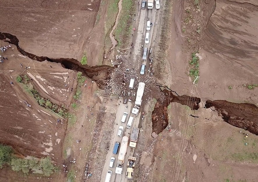 Again, in 30th April 2023, in the same road section approximately Six kilometers from Mai Mahiu Town, a crack emerged. It cut across the road rendering it unsafe to motorists. This incident led to the closure of the busy highway by KeNHA due to the dangers it posed to the motorists. The cause of the road crack was not immediately established but preliminary reports attributed it to the heavy rains. KeNHA in a statement said that the area has in the past been affected by earth’s tectonic movements.
Continuous Operating Reference Station (CORS)
In my opinion the best way to be sure would be to do actual measurements using Global Navigation Satellite Systems (GNSS) technology. This would involve installing Continuously Operating Reference Systems (CORS) stations, across the country hence forming a nationwide CORS network. These stations continuously log GNSS observables. They are able to detect even the slightest movements of tectonic plates or other underground movements.
CORS, can indeed be used to measure tectonic movements. The CORS are high-precision GNSS (Global Navigation Satellite System) receivers placed at specific locations and continuously collect satellite positioning data. These stations serve as reference points for accurately determining the positions of objects or points on the Earth’s surface.
 Suswa fault was caused by heavy rain flooding out deposits of volcanic ash. A CORS network can also be used to model the atmosphere (troposphere and ionosphere) over Kenya. Thsi will contribute to atmospheric studies and more accurate weather predictions. Countries like Japan that experience earthquakes more often are so advanced in their CORS network. The CORS studies resulting from those installations adequately predict the next earthquake. Since Kenya has not experienced natural disasters by way of earthquakes of a magnitude greater than 7.0 Ritcher scale, there has been little concern about the need to study the country’s seismic activities especially in the Rift Valley… >>> Continue Reading
Ad: Explore the world with Expedia

Flewflew: AI solutions provider in Africa

OrbiCollect: Mobile mapping made easier!

NSE Stock Market: Buy & Sell Shares