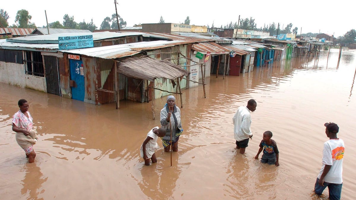
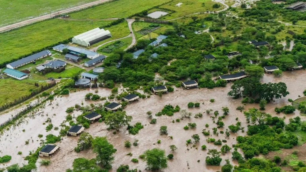
 Rapid Urbanization: Rapid urbanization in cities such as Nairobi, Kisumu and Mombasa has led to the expansion of informal settlements in flood-prone areas, where inadequate infrastructure exacerbates the impact of flooding on the vulnerable populations (See sample photo
Flooding Hazards
A hazard refers to any situation, condition, substance, or event that has the potential to cause harm, damage, or adverse effects to people, property, or the environment. Hazards include natural disasters such as earthquakes, floods, hurricanes, wildfires, as well as human-made hazards such as industrial accidents or pollution. GIS mapping of hazards is crucial in understanding their occurance and magnitude. Hazard mapping is a process used to identify, assess, and visualize potential hazards in specific geographic areas. Hazard mapping using GIS entails identifying and delineating hazard-prone areas that are exposed to the risk of flooding, based on the probability and magnitude of the flood events as it has been experienced in Kenya. The purpose of GIS hazard mapping is therefore to provide the valuable information for decision-making including the risk management, emergency preparedness as well as response planning.
 GIS and remote sensing can help disaster managers create and update hazard maps by using remote sensing data, such as optical and radar images, to detect and measure the extent and depth of the flood waters. GIS can also incorporate the hydrological models, such as rainfall-runoff and flood routing models, to simulate and forecast the flood scenarios under different conditions and instances. By overlaying the hazard maps with the latest satellite or drone images, land use and infrastructure data, GIS can help the disaster managers identify the critical assets and facilities that are at risk of flooding, including the roads, bridges, power lines, hospitals as well as schools. Hence, GIS helps disaster risk managers in making informed decisions on appropriate actions to be taken to mitigate flooding menace.
GIS Flooding Hazard Mapping Process
Hazard mapping is the first step towards understanding the nature, magnitude and extent of flooding menace in a given locality. To accomplish this, the following workflow should be adopted.
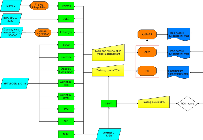
Field Data Collection: The process of gathering relevant data from various primary and secondary sources such as historical records, scientific studies, remote sensing, and GIS is a prerequisite. This data might include the information on past occurrences of flooding hazards, geological and environmental factors, population density, infrastructure, and land use among others. Presently, the adoption of drone technology has also proved to be an ideal and go-to solution in flood hazard data collection especially in areas which are risky or inaccessible. Flood modeling in GIS is also possible and may incorporate various datasets such as the Digital Elevation Model (DEM), Digital Surface Model (DSM), Rainfall data, satellite or drone images, land use/land cover and soil classification data as shown in figure 1 below.
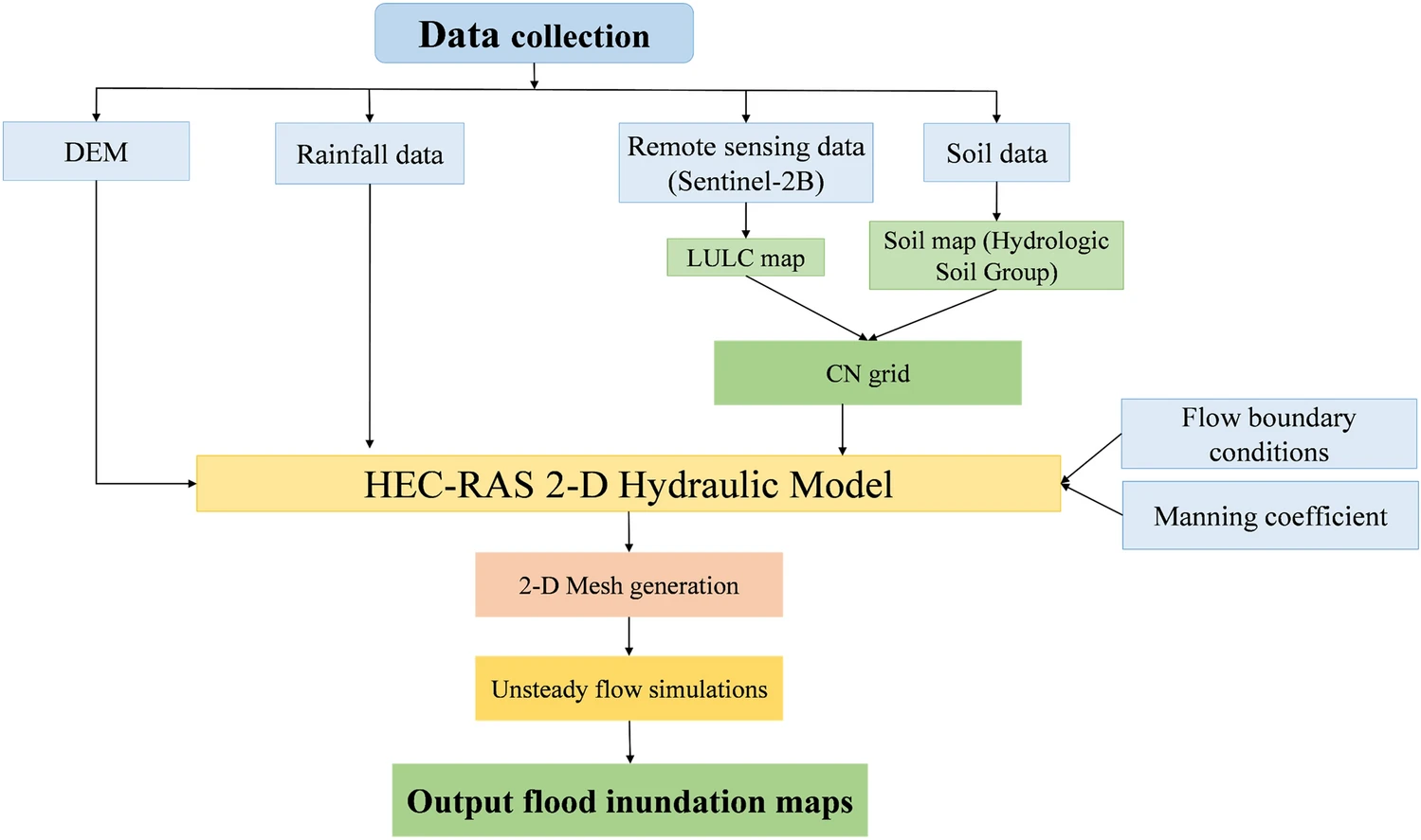
Figure 1: Flood Hazard Modeling in GIS (Source: nature.com)
Flood Risk Assessment: This process entails analyzing the collected data to assess the likelihood or probability and potential impact of different flooding hazards occurring in the area. This may involve considering the factors such as frequency, magnitude, vulnerability of populations and assets, and exposure to the flooding hazard.
 GIS Mapping and Analysis: Using GIS and remote sensing software or other mapping tools to visualize the spatial distribution of flooding hazards, vulnerabilities, and risks. The flood hazard maps can take various forms, including thematic maps, heat maps, and risk maps, and they often employ the use of colour coding or symbols to represent different levels of flood risks. The mapped data can also be shared on a GIS web or online map so that the information can reach a greater audience. Furthermore, a mobile GIS incident reporting app can also be developed and configured so that real time flood incidents can be mapped and data relayed to the central repository and later displayed via online maps.
GIS Data Interpretation: The information shared via the hardcopy maps or charts should be analyzed and examined to identify spatial patterns, trends, and areas of particular flooding concern. All stakeholders such as government agencies, emergency responders including The Red Cross, community groups, and residents in affected areas may also be involved in this process to provide insights and perspectives especially on a historical occurrences of floods. This will help in better planning, management and mitigation of future flooding hazards.
Communication to Public: Presenting the hazard maps (via online repositories or Geoportals) and associated findings in a clear and accessible manner to relevant stakeholders and the public is paramount. The effective communication is crucial in raising awareness, promoting understanding, and facilitating informed decision-making.
Risk Management and Planning: Using the information from flood hazard mapping to develop strategies and policies for reducing or mitigating the risks posed by such hazards. This may involve measures such as land-use planning, zoning regulations, infrastructure improvements, emergency response plans, public education campaigns, and environmental conservation efforts such as afforestation.
Assessing the Flooding Hazard in Kenya
- Declaration of all storm water outfalls as public spaces; Also land uses on the riparian reserves should be controlled and strictly monitored;
- Urgent baseline surveys of affected areas through Geospatial techniques like aerial survey and mapping should be undertaken;
- Repeat aerial mapping post-flooding should be undertaken to facilitate the post-analysis and hydrological studies. ISK note that continuous observation and data collection will inform future measures that will help curb the situation. The Government should ensure regular mapping as espoused in the draft Survey and Mapping Policy;
- Utilization of historic satellite data to identify and implement corrective measures such as storm drainage systems, channels, tunnels, dykes, and dams.
- Ensure that we conduct topographical surveys of construction sites before development. The surveys can also be used on all water bodies to determine the highest water mark of which human activities should be restricted.
- Harmonizing and strictly enforcing laws regarding riparian reserves to protect… Continue reading…
The efforts to address flooding in Kenya require a multi-faceted approach that integrates land-use planning, the infrastructure development, environmental conservation, the disaster risk reduction, and community resilience-building measures. Long-term solutions should aim at reducing vulnerability to flooding while enhancing the country’s capacity to adapt to changing climatic conditions.
GIS Course in Disaster and Hazard Risk Management
Get relevant GIS skills at our OGC training institution >>> GIS for Disaster and Hazard Risk Management Course

Article by: Felix Orina, MISK | @felixorina
Ad: Explore the world with Expedia

Flewflew: AI solutions provider in Africa

OrbiCollect: Mobile mapping made easier!

NSE Stock Market: Buy & Sell Shares